Pacific Crest Trail (PCT)

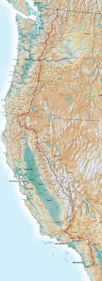
The Pacific Crest Trail or abbreviated PCT runs near the US west coast from the Mexican border near Campo through California, Oregon and Washington state up to Manning Park in Canada. With a total length of 2,663 miles it is one of the so called "Triple Crown" trails (Appalachian Trail, Pacific Crest Trail and Continental Divide Trail). All three trails are running north - south. I have hiked all three trails. The PCT passes through eight National Parks (Sequoia NP, Kings Canyon NP, Yosemite NP, Lassen Volcanic NP, Crater Lake NP, Mt. Rainier NP, North Cascade NP), 24 National Forests, many State Parks in California and land belonging to other government agencies. About 200 miles are still privately owned. For a long term safe guarding of the trail it is planned, as far as funds and the political will allows, to procure these sections too. Long stretches within the national parks and forests are so called wilderness areas. Much stricter rules then i.e. national parks apply here. No power tools are allowed. Downed trees must be cut by hand as much as any other necessary work.
I did prepare myself with a lot of information from internet sources (see LINKS) as well as the two books from Yogi. The bigger one which is ment as a preparation tool stayed at home. The smaller one with all the town and trail information was on my phone as PDF and only the current pages as paper copy in my pack. The other pages were in my bounce box to be regularly exchanged to be current.
Every four to eight days there is an opportunity to buy food for the next section. This is often directly on the trail when it passes through a place however small. Or there is a road access allowing to hitch hike into town. Not always but most of the time it is possible to take a shower and to wash all my clothes. And then of course a possibility eating a lot to recover lost weight. It was always a fight to carry enough food for a section but then not to overload the pack. As with all the equipment it is true for food too: every ounce counts.
I didn't want to cook any meals. Getting hot water yes. Starting on the Appalachian Trail I had freeze dried food only. This is mostly known as Mountain House food. Even so there are other suppliers too but they are the best known. I ordered it by phone from REI whom I joined years ago. This is a rather simple process. They shipped it to the second next supply place. It arrived in town all the time. It not only made preparing my meals rather simple but reduced my weight considerably.
I didn't carry any paper maps. Instead everything was loaded on my smart phone. To have a screen as large as possible combined with a good camera I bought the Experia arc S from Sony Ericsson. This gave me the following options within one piece of equipment:
-
- Free of charge PDF maps from Halfmile
- PCT elevation profile from Halfmile as PDF
- Software BackCountry Navigator with detailed trail from Halfmile (the maps were downloaded before starting as not to require an internet connection)
- GPS
- Trail and town description from Yogi as PDF
- Camera
- Radio
- MP3-Player
- and then of course a telephone
This not only allowed me to save a lot of weight but I could use the build in GPS to determine my exact position with BackCountry Navigator.
I recharged the cell phone whenever I could. Additionally I carried the small solar charger Arctic c1 mobile. This gave me enough power to always be able to use the phone. To avoid roaming fees I bought a prepaid SIM card with US phone number from AT&T. Their coverage was reasonable. There are only very few pay phones left.
Following an accident I had to replace my pants. I had slipped and thereby ripped my pants. Also my fome mattrass which was a regular companion when hiking the AT needed to be replace. And finally I bought from Six Moon Design the Poncho Tarp Gatewood. And here is my Equipment List.
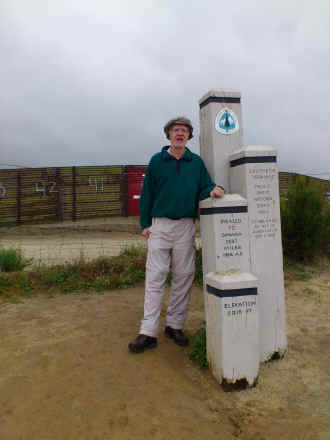
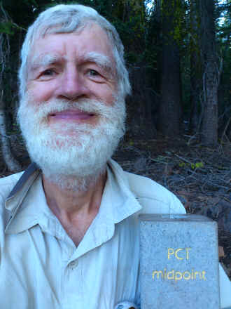
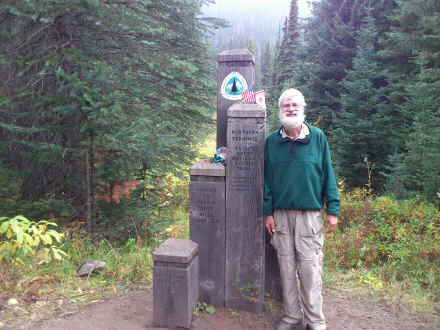
I have hiked this trail in 2012. I have now started a blog which can be viewed on the website Postholer, a site dedicated to the PCT. As I wanted to hike and not to write so much, this blog has a number of gaps. That's why I have now set up a description of my hike. As with all my hikes with photos. Furthermore I am showing with the following three photos how I have changed by not shaving at all.
Early morning on the first day at the Mexican border
Half way point!
The Canadian border after walking 2,668 miles!
© 2016 by Hamburger
Last updated on
30.12.2025
![]()